India daily weather forecast latest, March 24: Rains, thunderstorms to continue over Delhi, Punjab, Jammu & Kashmir


According to Skymet Weather, a western disturbance is over Jammu and Kashmir and adjoining areas. An induced cyclonic circulation is over Northwest Rajasthan and adjoining areas. A trough is extending from the Karnataka coast to North Madhya Maharashtra.
During the last 24 hours, rain and thundershower associated with snowfall have occurred over Jammu and Kashmir, Gilgit Baltistan, Muzaffarabad, Ladakh and Himachal Pradesh. Light rain occurred over Uttarakhand.
Scattered light rain and thundershowers with one or two moderate spells occurred over parts of Punjab, Haryana, north and western parts of Rajasthan and Vidarbha.
Kerala and parts of interior Tamil Nadu also witnessed moderate showers at few places. Isolated light rain occurred over Chhattisgarh, Jharkhand, North interior Karnataka and Arunachal Pradesh.
Day temperatures dropped over Punjab and Haryana by 2 to 4 degrees, Rajasthan, Gujarat, Madhya Pradesh and Chhattisgarh by 1 to 3 degrees.
") |
| Monday 5:30 am-Thursday 5:30 am (TWC Met Team ) |
During the next 24 hours, rain and thundershower activities are expected to continue at many places over the Western Himalayas with one or two heavy spells. The upper reaches of Jammu and Kashmir, Gilgit-Baltistan, Muzaffarabad, Ladakh, Himachal Pradesh and Uttarakhand will receive snowfall.
Many parts of Punjab, Haryana, Delhi, West and Central Uttar Pradesh and Rajasthan may receive light to moderate rain and thunderstorm. An isolated hailstorm is also expected over north-west India.
Scattered rain and thundershowers are possible over Madhya Pradesh, Vidarbha and Marathwada. Madhya Maharashtra, Chhattisgarh, Jharkhand, Kerala, south Karnataka and Arunachal Pradesh may receive light rain.
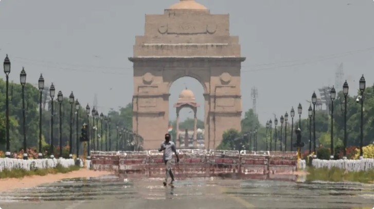
Parts of north and northwest India, including Delhi, have already started to experience blazing summer heat in March itself. And the mercury levels are waiting to soar high further in the coming months. However, some short respite is possible as wet weather conditions are on the cards over these aforementioned regions for the next two-three days.
According to the India Meteorological Department (IMD), a western disturbance (WD) has induced a cyclonic circulation over northwest Rajasthan. The WD is expected to intensify further and slowly move eastwards during the next two days.
Under the influence of these conditions, the moisture incursion is expected to increase over northwestern plains and adjoining the Western Himalayan Region. Along with this, the establishment and strengthening of southerly and southwesterly winds over the north Arabian Sea have been forecast from Monday (March 22) night onwards.
") |
| Representational image. (Sanchit Khanna/HT Photo) |
Therefore, fairly widespread to widespread rainfall or snowfall and thunderstorms with lightning are possible over Western Himalayan Region—which includes Jammu, Kashmir, Ladakh, Gilgit, Baltistan, Muzaffarabad, Himachal Pradesh and Uttarakhand—until March 24.
Some parts of Jammu, Kashmir, Ladakh, Gilgit, Baltistan and Muzaffarabad may also experience isolated hailstorms on Monday. Hail is possible over Himachal Pradesh and Uttarakhand as well on Monday and Tuesday.
Moreover, some parts of the Western Himalayan Region may also experience isolated heavy rainfall or snowfall on March 22 and 23. As per The Weather Channel met team, the peak fall over Jammu & Kashmir and Himachal Pradesh is expected on Monday and Tuesday with some ease on Wednesday. The three-day snow accumulation could add to a total of over 100 cm across the region.
Owing to these rough weather conditions, the met department has placed an orange alert over Himachal Pradesh and Uttarakhand for the next two days, while the latter will continue to remain in the same advisory for Wednesday as well. The advisory instructs residents to ‘be prepared' for rough weather. Meanwhile, Jammu & Kashmir has been placed under yellow watch for Monday and Tuesday, where the alert instructs ‘be aware’ of the local weather situation.
A day after parts of Delhi received trace rainfall coupled with strong winds, the hourly average air quality index (AQI) at 7am was recorded 222, in the “poor” zone, Hindustan Times reported. Central Pollution Control Board data shows that the overall AQI in Delhi on Monday was 196, categorised as “moderate” on the AQI. The India Meteorological Department (IMD) said that with more clouds passing over the city, there is a possibility of light rain continuing on Tuesday.
“More clouds are moving over the region. Though Delhi is not expected to receive any intense rainfall, the weather will be largely cloudy with light rain in some parts,” a senior Met official said on Monday.
 |
| Photo: Weather Online |
5-Day Nationwide Forecast
According to Weather.com, the ongoing western disturbance over the Western Himalayan region will retain its intensity on Tuesday. Moreover, the moisture incursion from the northern Arabian Sea over Northwest India will also continue until Tuesday. Under the influence of these meteorological features, the India Meteorological Department (IMD) has forecast:
(i) Fairly widespread to widespread rainfall/snowfall, thunderstorms and lightning are very likely over Western Himalayan Region (Jammu, Kashmir, Ladakh, Gilgit, Baltistan, Muzaffarabad, Himachal Pradesh and Uttarakhand) on 23rd March. Isolated hailstorms are expected over Himachal Pradesh on 23rd March and over Uttarakhand during 23rd-24th March. Isolated heavy rainfall/snowfall are also on the cards across Jammu, Kashmir, Gilgit, Baltistan & Muzaffarabad and Himachal Pradesh on 23rd March.
(ii) Fairly widespread to widespread rainfall, thunderstorms and lightning have been forecast over Punjab, Haryana, Chandigarh, Delhi and West Uttar Pradesh on 23rd March, and isolated to scattered showers over Rajasthan on the same day. Isolated hailstorms are also possible over Punjab, Haryana, Chandigarh, Delhi, West Uttar Pradesh and East Rajasthan on the day.
Accordingly, the IMD has issued an orange alert over Himachal Pradesh, Uttarakhand, Punjab, Haryana, Chandigarh, Delhi and West Uttar Pradesh and East Rajasthan on Tuesday. Meanwhile, the next western disturbance follows behind, and is expected to affect the regional weather from Saturday. Rain/snowfall events across Arunachal Pradesh will continue throughout this week, while changing their intensity at times. Thunderstorms may accompany the event.
Two cyclonic circulations—one over Southeast Madhya Pradesh and another over Coastal Karnataka—will also bring rainfall at isolated places over most parts of Central, Western and South Peninsular India during the next two days Thunderstorms and lightning at isolated places are also expected over Central and West India during the next two days, while isolated hailstorms are particularly likely over parts of Madhya Pradesh, Vidarbha, Madhya Maharashtra and Marathwada on March 23. These subdivisions will remain under an orange alert for the day.
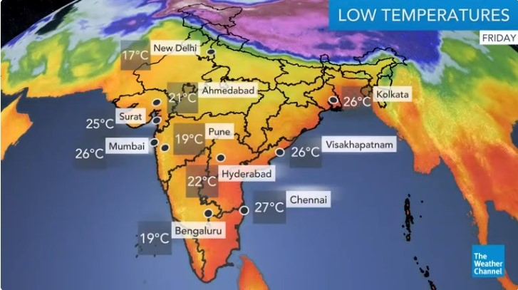
As for the mercury levels, maximum temperatures will be 3°C to 8°C lower than average across the Punjab plains until Thursday. Areas of over 40°C in Gujarat will widen as we head into the weekend. On the other hand, overnight minimums will be 3°C to 8°C higher than normal along coastal Maharashtra, Goa, and coastal Karnataka until Friday. However, no heatwave conditions are likely over the country during the next five days, the IMD adds.
 |
| Photo: IMD |
Regional Forecast
Scattered rain/snow and thunderstorms have been predicted over Jammu & Kashmir, Himachal Pradesh, Uttarakhand, and Arunachal Pradesh. Scattered rain and thunderstorms are likely over Kerala. Isolated snow/rain and thunderstorms are possible over Ladakh and Sikkim, and isolated rain and thunderstorms across Punjab, Assam, Karnataka, Tamil Nadu, Andaman & Nicobar Islands, and Lakshadweep. Max temperatures could possibly reach 40°C in some places of Gujarat, coastal Maharashtra, and Andhra Pradesh.
 | India daily weather forecast latest, March 19: A yellow alert for heatwave over Saurashtra and Kutch region A yellow alert was issued for heatwave over the Saurashtra and Kutch region. |
 | India daily weather forecast latest, March 18: Scattered rain, snow and thunderstorms to cover Jammu & Kashmir, Himachal, Arunachal Pradesh Isolated to scattered rainfall or snowfall are very likely to cover the Western Himalayan region (Jammu & Kashmir, Ladakh, Gilgit-Baltistan, Muzaffarabad, Himachal Pradesh and Uttarakhand) ... |
 | India daily weather forecast latest, March 17: Scattered rain expected over North West and Central India Many areas across Northeast India receive heavy showers and thunderstorms, parts of this region are expected to continue witnessing wet conditions for the next 3-4 ... |
Related Stories
 National
Vietnam News Today (Mar. 19): China Reaffirms Vietnam as Priority in Its Neighborhood Diplomacy
 National
Vietnam News Today (Feb. 10): Vietnam Hopes to Enhance Comprehensive Partnership With UAE
Recommended
 World
World
Vietnam Reaffirms Support for Effective Implementation of ASEAN's Five-Point Consensus
 World
World
Algeria Shares Healthcare Expertise to Advance Africa's Pharmaceutical Self-Reliance
 World
World
Modi's Asia-Pacific tour highlights India's regional engagement
 World
World
Australia-India Partnership on Cyber, Critical Technologies and Supply Chains
 World
World
Venezuela Declares Seven Days of National Mourning for Earthquake Victims
 World
World
Europe Faces Historic Heatwave, More Than 1,000 Deaths Reported
 World
World
Myanmar Destroys Over 50 Tons of Drugs on International Anti-Drug Day
 World
World