UK and Europe daily weather forecast latest, January 19: Flood warnings issued across much of the UK
UK's weather forecast
According to Express, warnings have been issued across much of the country with Met Office amber warnings for rain in place this week.
Britain is facing more than 80 warnings and alerts with heavy rain expected to fall across the country. Forecasters have warned up to six inches of rainfall may hit parts of the country over the coming days. But where in the UK have seen flood warnings and alerts implemented as torrential downpours are anticipated to hit?
The Met Office issued amber severe weather warnings across parts of the country on Sunday. The amber weather warning advises of heavy rainfall combined with snowmelt across the hills which will likely lead to flooding.
A broad area of rainfall is forecast to hit the region later on Monday and remain across the area for the following 36 to 48 hours.
Rainfall will be heaviest and most persistent across western facing hills. Over the course of this time, up to 4.7 inches (120mm) of rainfall is expected across the southern Pennines and northern Peak District.
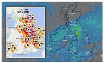
 |
| Flood warnings mapped: (Image: ENVIRONMENT AGENCY/WINDY.COM) |
Up to three inches of rainfall is expected to fall widely within the warning areas and the rain will lead to rapid melting of any remaining lying snow across the higher peaks which may add a further 0.4 inches (10mm).
Strong winds will also accompany the rainfall and may add to travelling difficulties across areas higher and more exposed routes.
A second yellow weather warning is in force from midnight on Tuesday to 12pm on Thursday. There will be spells of prolonged and heavy rain which may lead to flooding and disruption to travel in places.
The forecast will include several days of persistent and occasionally heavy rain which are expected to affect the region.
The heaviest and most persistent rain is likely to be across Wales and the high ground of northern England (Pennines).
By early Thursday, up to 2.4 inches (60mm) of rain is expected to fall widely across the warning area. A further six inches (150mm) is possible across high ground of Wales and northern England. Northern Wales could potentially see up to eight inches (200mm) of rainfall. Melting snow across higher parts of the Pennines may exacerbate the potential for flooding.
 |
| Flood warnings mapped: Flood risk over the next five days (Image: ENVIRONMENT AGENCY) |
Forecasts predict strong winds will also accompany the rainfall and may add to travelling difficulties across areas higher and more exposed routes.
The Environment Agency has issued several flood alerts and warnings across England on Monday. Currently, there are 71 flood alerts where flooding is possible and preparedness is advised. There are an additional 12 flood warnings where flooding is expected and immediate action is required.
Local river and surface water flooding is probable across parts of the north of England during Tuesday, Wednesday and Thursday, and possibly more widely across Wales and parts of central, eastern and northern England on Tuesday, Wednesday and Thursday.
The Environment Agency advises properties could flood and there could be travel disruption. Local river and surface water flooding is also possible elsewhere across parts of central and southern England on Wednesday and Thursday.
Land, roads and some properties could flood and there could be travel disruption. One flood alert is also in place in Wales across south Pembrokeshire. Natural Resources Wales advises due to restrictions at the tidal outfall, river levels in the River Ritec in the Salterns area of Tenby are in place on Monday.
 |
| Flood warnings mapped: Met Office weather warnings in effect on Tuesday and Wednesday (Image: MET OFFICE) |
More rainfall is expected across Wale on Monday afternoon and will persist overnight. Heavy downpours are expected in parts before easing in intensity for many after midnight. Torrential rain will continue on Tuesday and Wednesday leading to a risk of flooding in places.
On January 19
According to Weather Online, low pressure tracks across Ireland and over the UK on Tuesday. Cloud and rain spread across much of the country as the associated fronts continue to pass through. Winds strengthening too. Rain could largely clear across much of central and southeastern England for a time before more rain pushes in later on in the day and overnight. Milder air for most is expected, with the exception of northern Scotland where it will stay largely dry and cool. Highs at 8 to 12C for Ireland, England and Wales but cooler for Northern Ireland and Scotland with highs of just 3 to 5C.
Rain continuing, heavy and persistent over central parts with some snow for Northern Ireland and southern Scotland. Windy and mild in south. Colder with sunny spells and showers to north, Met Office reported.
 |
| Photo: Weather Online |
Outlook for Wednesday to Friday
Remaining extremely unsettled with heavy rainfall, and the potential for some snowfall and strong winds across southern and more especially central areas. Much colder in the north with wintry showers.
Europe's weather forecast
Dry and fine for Spain and Portugal once again with the Balearic islands also fairing well. Any rain will soon clear southern and eastern areas of Sardinia and Corsica. An improving day from the north across Sicily as well as Italy with winds easing here. Rain, sleet and snow across Greece should slowly ease off. Cloudy but mostly dry across Turkey although rain will continue to affect southern areas.
Largely dry across France and the Low Countries. Cloudy with patchy rain, sleet and snow affecting parts of Germany as well as the Czech Republic during the day. Morning sleet and snow in Switzerland will soon clear but will continue to affect Austria throughout the day. Mostly dry for Poland although snow is expected in the far west later.
Staying mostly settled across Scandinavia although snow will continue to affect southern areas of Norway and Sweden. Largely dry across Finland. Denmark, however, will see rain, sleet and snow, falling heavy in places, in the morning, before clearing to the east later. Wintry showers through the Baltic States.
 |
| Photo: Stirimeteo |
 |
| Photo: Stirimeteo |
On January 19
According to Weather Online, largely dry and bright for Portugal, Spain, the Balearic Islands, Corsica and Sardinia. Cloud thickens to the northwest of Iberia with rain arriving here later. Largely dry and fine for Italy and Sicily with scattered showers developing to the west later. Early showers ease over southern Greece to give and dry and bright day here. These conditions extend into western Turkey though eastern areas see further snowfall.
Breezy with outbreaks of rain over northern France and the Low Countries. Dry over the rest of France with the best of the sun to the south. Breezy with outbreaks of rain, sleet and snow spreading across Germany into the Czech Republic, Slovakia and Poland later. Mostly dry and fair for Switzerland and Austria with some snow possible to the north.
 |
| Photo: Weather Online |
Wet and windy for Denmark. Mostly dry and fair across the rest of Scandinavia. Some patchy sleet and snow into the far south of Norway and Sweden. Isolated snow showers also develop over the southern Baltic States.
 | UK and Europe weather forecast latest, January 15: Snow warnings issued as icy blast sweep the UK The UK is forecasted to cope with heavy snow covering many parts and a rare amber alert was issued. Meanwhile, cold weather is expected in ... |
 | UK and Europe weather forecast latest, January 14: Ferocious deep freeze hits with snow and wintry conditions The UK is forecasted to cope with 14 inches of snow to fall as well as wintry conditions. Meanwhile, cold sets to batter in northern ... |
 | UK and Europe weather forecast latest, January 13: Low pressure brings extreme wintry conditions and heavy snow The UK is forecasted to bear extreme wintry conditions and heavy snow to much of the country. Meanwhile, windy, snow are expected in Scandinavia, rain ... |
Related Stories
 National
Vietnam News Today (July 6): China-Vietnam Ties Extend Beyond Bilateral Relations
 National
Vietnam News Today (Jun. 17): Vietnam Promotes Int’l Cooperation on Ocean Governance at United Nations
Recommended
 World
World
Vietnam Reaffirms Support for Effective Implementation of ASEAN's Five-Point Consensus
 World
World
Algeria Shares Healthcare Expertise to Advance Africa's Pharmaceutical Self-Reliance
 World
World
Modi's Asia-Pacific tour highlights India's regional engagement
 World
World
Australia-India Partnership on Cyber, Critical Technologies and Supply Chains
 World
World
Venezuela Declares Seven Days of National Mourning for Earthquake Victims
 World
World
Europe Faces Historic Heatwave, More Than 1,000 Deaths Reported
 World
World
Myanmar Destroys Over 50 Tons of Drugs on International Anti-Drug Day
 World
World