UK and Europe weather forecast latest, January 8: Ferocious Arctic blast to cover the UK with heavy snow as temperatures plummet


UK's weather forecast
Forecasters warn more severe cold snaps are on the way later this month, as cold air outbreaks move in from Scandinavia, Express reported. The weather front looks set to spark unsettled conditions, including plummeting temperatures and heavy snow across the whole country, according to the latest weather charts.
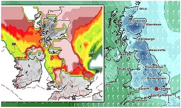
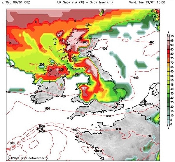
The wintry conditions are expected to hit the UK by Tuesday January 19, with a weather chart by Netweather showing snow is forecast for much of Britain.
The map, valid for 6pm, shows much of Scotland and the north of England covered in patches of white and red, indicating between an 80-100 percent risk of snow.
Parts of Wales, Northern Ireland and the Midlands are also covered by the bright colours. The east of England has a moderate snow risk, as indicated by the yellow and green colourings.
By 6am the next morning the snow risk has increased significantly, with almost the entirety of Scotland, northern England and Wales showing a 100 percent risk of snow.
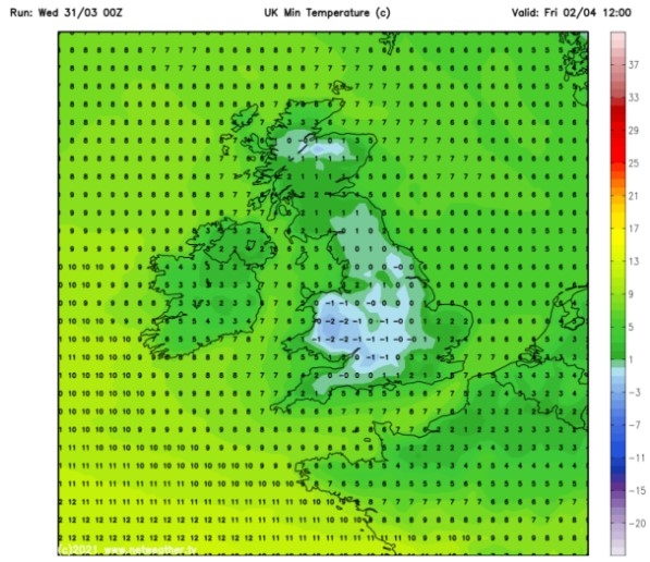
</td> </tr> </tbody> </table> <p style= "UK and Europe weather forecast latest, January 8: Ferocious Arctic blast to cover the UK with heavy snow as temperatures plummet") As Thursday morning approaches, the snow risk moves southwest with the West country and the south of England expected to be blanketed in snow at 6am. As Thursday morning approaches, the snow risk moves southwest with the West country and the south of England expected to be blanketed in snow at 6am. By 6pm the weather front moves further east, as the snow risk chart shows the whole of the south of England, including the capital, turn white indicating a 100 percent chance of snowfall. Weather charts also show Friday, January 22 is set to bear the brunt of the wintry conditions. Snow depth charts by WXCharts show parts of Scotland can expect 7.5inches (19cm) of snow by 6am, while the north of England is forecast to see up to 4.3inches (11cm). Wales is expected to receive up to 3.5inches (9cm), with the south of England forecast to receive similar amounts of snow, according to the chart. Alongside the snowfall, temperatures are also forecast to plummet well below freezing. A second weather map focusing on the minimum temperature by WXCharts forecasts the mercury could fall to as low as -12C in parts of Scotland at 6am on Friday January 22.
|
</td> </tr> </tbody> </table> <p style= "UK and Europe weather forecast latest, January 8: Ferocious Arctic blast to cover the UK with heavy snow as temperatures plummet") The Met Office has said the period between Wednesday, January 20 and Wednesday, February 3 is set to be characterised by unsettled conditions, as the north sees cold air outbreaks move in from Scandinavia while the south is expected to have milder conditions.
The Met Office has said the period between Wednesday, January 20 and Wednesday, February 3 is set to be characterised by unsettled conditions, as the north sees cold air outbreaks move in from Scandinavia while the south is expected to have milder conditions. 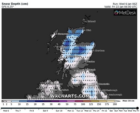 of snow by 6am on January 22 (Image: WXCHARTS)</td> </tr> </tbody> </table> <h3 style= "UK and Europe weather forecast latest, January 8: Ferocious Arctic blast to cover the UK with heavy snow as temperatures plummet") According to Weather Online, an area of snow showers affects eastern Scotland and drifts into North East England on Friday. They will be broken cloud for many areas with some sleet or snow flurries here and there. The highest risk of these is through the Midlands and Wales. Central and western Scotland as well as match of Ireland should be dry and bright but remaining cold. Some showers affects eastern parts of Ireland where it will also be breezy. Highs at 1 to 3C.
According to Weather Online, an area of snow showers affects eastern Scotland and drifts into North East England on Friday. They will be broken cloud for many areas with some sleet or snow flurries here and there. The highest risk of these is through the Midlands and Wales. Central and western Scotland as well as match of Ireland should be dry and bright but remaining cold. Some showers affects eastern parts of Ireland where it will also be breezy. Highs at 1 to 3C.  Europe's weather forecast

 Cloud and outbreaks of snow in Denmark. Further
 Related Stories
 World
World
Europe Faces Historic Heatwave, More Than 1,000 Deaths Reported
 National
Vietnam News Today (Jun. 18): Vietnam, Argentina Look to Stronger Comprehensive Partnership
Recommended
 World
World
Vietnam Reaffirms Support for Effective Implementation of ASEAN's Five-Point Consensus
 World
World
Algeria Shares Healthcare Expertise to Advance Africa's Pharmaceutical Self-Reliance
 World
World
Modi's Asia-Pacific tour highlights India's regional engagement
 World
World
Australia-India Partnership on Cyber, Critical Technologies and Supply Chains
 World
World
Venezuela Declares Seven Days of National Mourning for Earthquake Victims
 World
World
Myanmar Destroys Over 50 Tons of Drugs on International Anti-Drug Day
 World
World
French Adventurer to Cycle 19,000 km to Vietnam, Taking on 14 of Asia and Europe's Highest Passes
 World
World